CaneBrake
Well-Known Member
Need some help from some whitetail gurus. I have the chance to take someone on their first REAL hunt for whitetail and this is somewhat of a last minute thing. I'm trying to guess some good spots based on satellite and topo maps. It's public land so it's hunted hard but most people don't stray from the road. Had I known earlier I would've been scouting this area all summer because I would like for it to be successful for them. Obviously, a buck would great for them but they would be happy with a doe. It'll be the week of Thanksgiving, so later rut. I'm hoping you guys might have some input. I have some other spots picked out too if you guys would like to see them
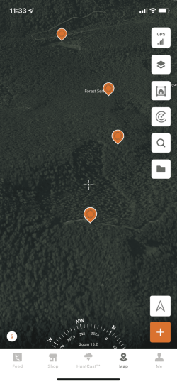
I have four points marked that I think my be of interest based on my experience from whitetail movement but I'm not a guru by any means. They are based off a main dirt road. I still think they are far enough away from the road and hard enough walks that no one will attempt to go there.
Points from top to bottom of both pictures:
#1 is an area near a stream that was timbered or burned off a while back. It's about 700 yds off the road and about a 200ft drop in elevation.
#2 is the main dirt road. I'm hoping it will be closed because most people here are lazy. They will walk 200yds off the road and call it quits.
#3 is settled on the low end of converging saddles that create a depression of sorts. This entire depression was also timbered or burned off a while back. This point and #4 are higher elevation which I thinking might be where the deer go once the pressure hits
#4 is on the high end of the depression.
Just behind #3, and #4 you will see a smaller access road that I'm hoping will be closed to the public but I don't know for sure. #4 is basically right on the road. I'm thinking these burned or timbered areas are going to be full of briars and brush and the deer are going to favor them with the pressure.
Let me know what you guys think.
Attachments
Last edited:

