Hugnot
Well-Known Member
Columbus Day -- October 12, 1492 - Christopher Columbus, an Italian from Genoa Italy - set foot on dry ground at Guanhami island, Bahamas after long trip across S Atlantic. Columbus commanded the Santa Maria, about 62 feet long with a crew of 40. Columbus was a devoted navigation student and made repeated attempts to fix latitude using a quadrant to determine angular elevations of various objects like sun and north star. Lots of latitude fixes were made, all not very accurate (angular measurement using plumb line device on rolling & pitching vessel). He essentially used a compass and DR (timed floating chip passing alongside) with hour glass at set at half hour intervals and sailed west until land happened. Good accurate clocks had not happened at that time. Subsequent economic efforts had adverse consequences.
Then there was the Viking settlement at L'Anse aux Meadows in Newfoundland Canada, some time between 990-1050, like 592 - 442 years before Columbus' trip.


The Vikings, did not document their voyages as well as Columbus, a paid mariner.
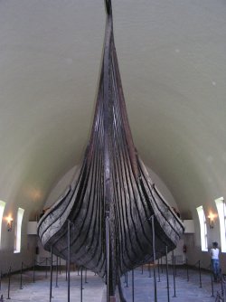
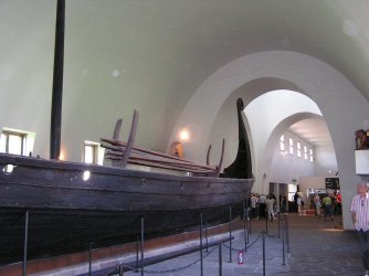
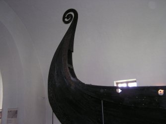
Exploratory Viking vessels were about 65 feet long. The smaller Viking vessels used to for trading throughout Europe and possibly some N. Africa ports were some 20 feet shorter and could be transported over land from water body to water body. These vessels were relatively light weight, lap construction and flexible. The Viking trips across the horrible N. Atlantic in open boats must have been real nasty. The Vikings were real good sailors.
The Viking probably did not have magnetic compasses. They determined latitude using something that looked like a sun dial to get sun lines. When the sun was not shining thru clouds the Sun Stone was used, a calcite crystal. Calcite crystal is bi-fringent, like light splits into 2 polarized waves (streams of particles) when it enters the Sun Stone. Upon looking thru the Sun Stone at the brightest area above and rotating it until the 2 bright areas converged the approximate location of the sun could be determined and sort of a sun line made, like at high noon. A fix angle on the North Star will give sort of a latitude. When birds were seen and off shore winds at night fall blew land smells out, land was near. A lead line hitting bottom confirmed it.
Viking depredations & hostility were more known than their artistic and tech abilities.
Then there was the Viking settlement at L'Anse aux Meadows in Newfoundland Canada, some time between 990-1050, like 592 - 442 years before Columbus' trip.


The Vikings, did not document their voyages as well as Columbus, a paid mariner.
Exploratory Viking vessels were about 65 feet long. The smaller Viking vessels used to for trading throughout Europe and possibly some N. Africa ports were some 20 feet shorter and could be transported over land from water body to water body. These vessels were relatively light weight, lap construction and flexible. The Viking trips across the horrible N. Atlantic in open boats must have been real nasty. The Vikings were real good sailors.
The Viking probably did not have magnetic compasses. They determined latitude using something that looked like a sun dial to get sun lines. When the sun was not shining thru clouds the Sun Stone was used, a calcite crystal. Calcite crystal is bi-fringent, like light splits into 2 polarized waves (streams of particles) when it enters the Sun Stone. Upon looking thru the Sun Stone at the brightest area above and rotating it until the 2 bright areas converged the approximate location of the sun could be determined and sort of a sun line made, like at high noon. A fix angle on the North Star will give sort of a latitude. When birds were seen and off shore winds at night fall blew land smells out, land was near. A lead line hitting bottom confirmed it.
Viking depredations & hostility were more known than their artistic and tech abilities.
Last edited:
